
I think Death Valley has been given a bad rap. Many who have already visited would probably agree. Obviously, there must be more than one or two reasons why this unique area is thought to be a forsaken place. For one thing—there’s its name. Death, and all that connotes. Not exactly an inviting nomenclature. And then, there’s the desert thing. Combine them together and you’ve really got a dreadful picture. Dry, for sure. Life-sapping, more likely. Hot—morbidly so. Empty. Inhospitable. Unforgiving. A hostile place having no redeeming qualities. For sure, its reputation is sorely in need of some redemption. I’ll go on record and say “Come and see for yourself—this park has hidden attractions. And the fun is in the hunt.”

And so, after a few hours’ drive across the Mojave National Preserve, we entered Death Valley. I had reserved four days at Furnace Creek Campsite with a premier electrical site. Upon our approach Chris turned to me and asked “Exactly what will we do here for FOUR days?” Plenty, I said. Not realizing what an understatement that answer was.

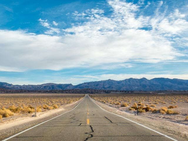
The road stretched out before us. Seemingly endless. An unchanging landscape. Okay, call it barren. Or desolate. I had yet to discover this park’s attributes. They certainly don’t glare in your face upon first sight. And Chris still had his doubts.
Established in 1994, Death Valley is our largest national park in the lower 48, and the fourth largest in our country. Its claims to fame are its extremities—North America’s driest (less than 2” of rainfall annually), hottest (setting a record of 134 degrees in 1913), and lowest (282 feet below sea level) location. Even with these features, the park still receives nearly a million visitors each year—but not many come in the summer (no surprise there).

In 1849 immigrants bound for California’s gold fields strayed into the 120-mile long basin, enduring a two-month ordeal of “hunger and thirst and an awful silence.” One of the last to leave looked down from a mountain at the narrow valley and said, “Good-bye, Death Valley.”

The moniker belies the beauty in this vast graben, the geological term for a sunken fragment of the Earth’s crust. Here are rocks sculptured by erosion, richly tinted mudstone hills and canyons, luminous sand dunes, lush oases, and a 200-square-mile salt pan surrounded by mountains, one of America’s greatest vertical rises. In some years spring rains trigger wildflower blooms amid more than a thousand varieties of plants.

Our campsite turned out to be a winner . . . and brought a big surprise. Besides providing power, we had full hookups—sewer and water included. Out of the 136 sites in Furnace Creek Campground, only eighteen come with full hookups. Chris was beginning to be won over.

Evening was setting in by the time we finished setting up. Not completed isolated in the heart of Death Valley, Furnace Creek Campground is centrally located to other accommodations—Furnace Creek Ranch is nearby, having cabins and dining options, while the luxurious Furnace Creek Inn with more posh lodging and dining, is a mile drive away. But looking at the view we had out our door, and the conveniences our home-on-wheels had to offer, we were quite satisfied with what we had. In fact, Chris was beginning to wonder if 4 days would be enough.

Furnace Creek Campground is an ideal location for exploring other parts of Death Valley. Even an early morning or evening walk along the Airport Road that runs next to the campground offers stunning views of the surrounding mountains and south towards Badwater Basin. Our first sunset that night gave us a good taste of what was in store.

Spectacular skies weren’t just for sunsets here in Death Valley. Early the next morning I was out before dawn. Not knowing what to expect or where to be, I was stunned by the sight of sunrise in a simple wide expanse of flat rocky land.

Wow! This place has potential!
To gain some perspective and get a feel for what this park had to offer, we did some driving along the paved park roads our first day. Encompassing more than 3,000,000 acres of California’s Mojave Desert, Death Valley National Park has not only low desert land of sparse vegetation, but is also flanked by mountain ranges both to the east and the west. It is a landscape of stark contrasts.


Driving west from Furnace Creek, passing through the small commercial area of Stovepipe Wells, the road begins to rise in elevation. You leave the basin of Death Valley and cross over a mountain pass.

The Panamint Mountains are the largest and highest in Death Valley. Flanked by the vast depth of Death Valley to the east and Panamint Valley to the west, they stand alone in grand isolation. This biological “island” differs dramatically from the low desert. Pinion pine and juniper woodlands above 6,000 feet provide habitat for mule deer and mountain lions, while rugged canyons and lofty ridges are home to bighorn sheep.

Parked high above the desert floor.
Another evening was coming on as we made our way down from the elevations and crossed the low-lying basin past Stovepipe Wells. The strange shrub formations dotting the rocky terrain are a distinctive area known as the Devil’s Cornfield. It is one of the largest forms of vegetation you’ll find growing in Death Valley.

Ahead of us were the Funeral Mountains, establishing the park’s east boundary. As if to give proof that last night’s fiery sky was no fluke, another brilliant sunset set the skies ablaze. Giving even Chris pause to admire, we were both coming under the spell of Death Valley’s pull.

I had my sunrise location selected for the next morning and you can be sure I left in the predawn darkness. Badwater Basin, with an elevation of 282 feet below sea level, is the lowest point not only in this park, but in the whole of North America. Here, at a visitor turn-out, you’ll see a small pool of “bad water.” The spring-fed water is heavily saturated with the accumulated salts of the surrounding basin. What is bad to drink is in contrast very good for reflecting the image of Telescope Peak at first light of day. When the sun breaks over the Funeral Mountains, the light hits the Panamint Range and that makes for one outstanding Death Valley image. I got my shot in that early morning dawn.

As a point of fact, Telescope Peak, at an elevation of 11,049 feet, is the highest mountain in Death Valley. The vertical drop from that peak to the Badwater Basin is twice the depth of the Grand Canyon.
If you make it to this special sunrise spot, don’t be in a rush to turn and leave. Take time to look out over the landscape—the salt flats of Badwater Basin cover nearly 200 square miles. They are among the largest protected salt flats in the world. Standing at its edge, scanning over the broad expanse, the immensity is difficult to comprehend, its timelessness hard to grasp. The emptiness is profound and the experience is memorable.

The sights we took in, the scenery we saw, as our second day unfolded brought a similar realization to both Chris and myself. Four days in Death Valley would not be enough. The more we were seeing, the more we wanted to take in. Without being rushed. Death Valley was more than a dry, parched desert and to fully appreciate it requires you to savor what you see. We talked to the campground ranger about extending our stay a couple days or more. If we didn’t mind switching sites, she thought we’d be able to stay.

So, what filled those coming days, keeping us on the go and soaking in the scenes? Plenty, you can be sure, but what those activities were remains for my second edition. These photos have just begun to scratch the surface of this wonderful park . . . our explorations just beginning. If pictures like these have caught your interest, then there are more to come. A second post is hopefully not far behind.

And a full moon just added to the magic.

Hanging out a little longer,
Airstream Travelers,
Melinda and Chris
